Hohokam Legacy: Desert CanalsHohokam Legacy: Desert Canals(Pueblo Grande Museum Profiles No. 12)
Jerry B. Howard
IntroductionVisitors to the Salt River Valley are often surprised to discover a fertile agricultural region
flourishing in the arid Arizona desert. However, these modern agricultural achievements are not without
precedent. From A.D. 600 to 1450, the prehistoric Hohokam constructed one of the largest and most
sophisticated irrigation networks ever created using preindustrial technology. By A.D. 1200, hundreds
of miles of these waterways created green paths winding out from the Salt and Gila Rivers, dotted with
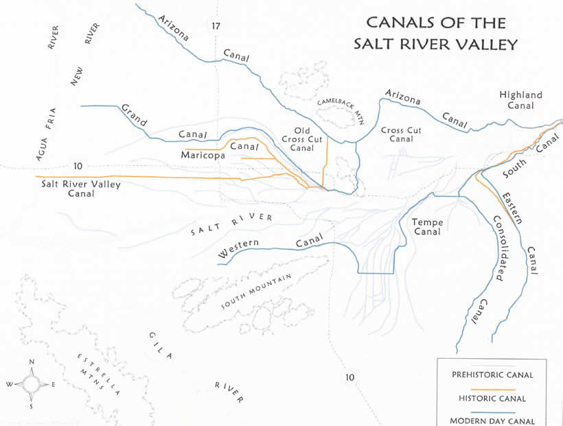
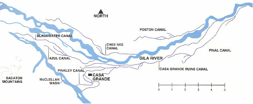
large platform mounds (see Illustrations 1 and 2).
The remains of the ancient canals, lying beneath the streets of metropolitan
Phoenix, are currently receiving greater attention from local archaeologists. We are only now beginning
to understand the engineering, growth, and operation of the Hohokam irrigation systems. This information
provides new insights into the Hohokam lifestyles and the organization of Hohokam society. 
Illustration 1. Extensive Canal System built by the Hohokam and others to divert water from the Gila River. (Source: Salt River Project)
 | Click on the image for a larger version. |
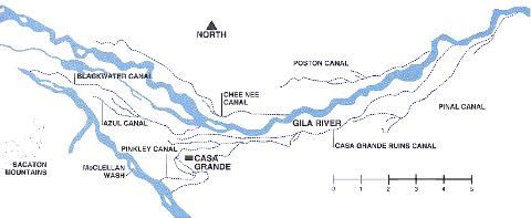
Illustration 2. Extensive Canal System built by the Hohokam to divert water from the Gila River. (Source: Southwest Parks and Monuments Association)
| Click on the image for a larger version. |
Early Records of the Prehistoric CanalsWhen the first explorers, trappers, and farmers entered the Salt River Valley, they were quick to
note the impressive ruins left by the Hohokam. Villages containing platform mounds, elliptical ballcourts
and trash mounds covered with broken ceramic pots and other artifacts existed throughout the valley.
Stretching out from the river was a vast system of abandoned Hohokam canals that ran from site to site
across the valley floor. In the mid-1800s, the testimony of these ancient canals to intensive prehistoric
irrigation, along with the success of the contemporary Pima Indian farmers, led Jack Swilling, John Y.T.
Smith and the early Mormon pioneers of the Lehi settlement to begin the process of building a new community
founded on irrigation agriculture. The ancient canals served as a model for modern irrigation engineers, with the earliest historic
canals being formed largely by cleaning out the Hohokam canals. The ancient ruins and canals were a source
of pride to the early settlers who envisioned their new agricultural civilization rising as the mythical
phoenix bird from the ashes of Hohokam society. The canals were useful at times, being employed as wagon
roads. In contrast, canals created unwanted channels through areas being developed by modern farmers. When
a farmer purchased land, the area impacted by a prehistoric canal was often calculated and subtracted from
the purchase to offset the costs incurred by filling it. As modern farmers began to fill in the traces of the prehistoric canals, several prominent citizens
became interested in these prehistoric monuments. They prepared maps showing the locations of canals,
villages and mounds that form the basis of Hohokam scholarship today. James Goodwin, a local farmer, produced
a map of the canals on the south side of the Salt River in what is now Tempe, Mesa and Chandler. Herbert
Patrick, a professional cartographer and surveyor, mapped canals on the north side of the Salt River. In
1922, Omar Turney, the City Engineer for the City of Phoenix, used these early maps combined with his own
knowledge of local prehistory to publish the first comprehensive map of the prehistoric ruins and canals
of the Salt River Valley. The most extensive records were made by Frank Midvale, an archaeologist who
devoted his life to recording the traces of the Hohokam as the remains of their culture were destroyed by
the rapid expansion of modern agriculture and urban growth. The Development of Prehistoric Irrigation in the Salt River ValleyAt about the same time of Christ, people began to move into the Salt and Gila River Valleys. Little
is known about these people who established the first small hamlets along the terraces above the Salt River.
They appeared to have lived a sedentary agricultural lifestyle, establishing fields along the margins of the
river. They probably relied on floodwater farming techniques, planting in the wet soil in areas that had been
inundated when spring runoff swelled the rivers beyond their banks. Perhaps as early as A.D. 50, these early
inhabitants introduced a new technology, canal irrigation. This technology would eventually give form to the
unique prehistoric culture of southern Arizona known as the Hohokam. Canal irrigation was previously employed
by peoples living along rivers and small drainages in Mexico, although their canal systems never attained the
size and sophistication of the Hohokam canal systems. The earliest Hohokam irrigation systems may have been
small canals located close to the river. In this location, the early canals would have been particularly
susceptible to destruction by flooding. Sometime between A.D. 600 and 700, Hohokam irrigation engineers designed the first large canals, capable
of transporting large quantities of water onto the upper, or second, terrace of the Salt River. By the early
Colonial period (A.D. 700 to 900), large integrated canal systems were established on both the north and south
sides of the river. These canals were often monumental in their size and scope. Many of the canals were over
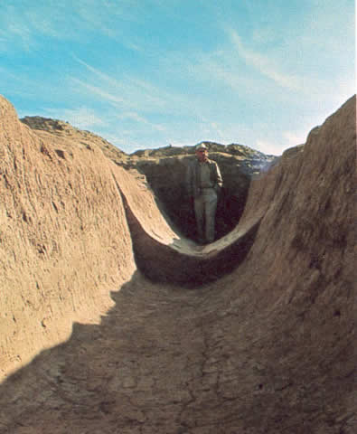
12 miles in length, with the largest recorded Hohokam canal extending for 20 miles (32 km) (See
Photograph 1). Two large prehistoric canals are still preserved in Park of the
Four Waters, located in the southern portion of the Pueblo Grande Museum and Archeological Park. The canals
measure 26 and 18 meters in width and approximately 6.1 meters in depth. Canal System 2, the large system
that heads on the Salt River at Pueblo Grande, was probably capable of irrigating over 10,000 acres of land. Canal Engineering and OperationRecent research, largely conducted in the corridors of the expanding freeway system, is providing new
information concerning the engineering of Hohokam canal systems. The Hohokam engineers were keenly aware of
the local topography, the dips and slopes, drainages and soils. They developed a sophisticated knowledge of
the flow of water through channels and developed a series of techniques for delivering water to the surface
of the fields. Each technique was appropriate for a specific topographic setting such as steep slopes and flat
river terraces. The canal systems were designed with respect to the needs and characteristics of the
environment. The canal systems contained a series of physical elements. Where the canal met the river it is likely
that a weir would be constructed. A weir is a dam that reaches into, but does not completely cross, the river.
It raises the level of the water in the river and directs it into the canal. Inside the canal, a headgate (a
large water control gate), was probably constructed to regulate the amount of water entering the canal. The
main canals transported the water away from the river toward the fields. Research has shown that the main
canals are very large at their junction with the river, but reduce in size as they progress toward their
terminus. As the amount of water traveling through the canal decreases through discharge onto fields,
evaporation and seepage, the size of the channel carrying the water is reduced. By reducing the channel,
the velocity of the water (the speed it travels through the channel) remained relatively constant and between
two critical thresholds: if the water traveled too fast, it eroded the sides of the canal; if the water slowed
down, particles of soil would settle out of the water, causing the canal to quickly "silt up," and require
increased maintenance. Distribution canals took water from the main canal system and transported it to the fields. They were
also used to manipulate the relationship between the water level in the canal and the ground surface. Several
types of water control features were used to operate distribution systems. Diversion gates have been found at
the junctions of main and distribution canals to regulate water flow. Tapons or water control gates were often
placed inside the main and distribution canals. When closed, the tapon would cause the water to back up and
rise in elevation, creating a "head of water." Through the use of water control features, the Hohokam were
able to create a highly sophisticated irrigation system. Canal ConstructionBuilding the Hohokam canals required a substantial investment of human labor. The soil was removed by
hand, probably using large wedge-shaped pieces of stone called "stone hoes," and wooden digging sticks to
loosen the soil. The soil could then be removed from the canal using large baskets. Variations on the simple
"leveling frame," used in many preindustrial agrarian societies, could have been employed to establish canal
gradients. It has been suggested that water may have been carried along in the canal during construction to
wet down or "loosen" the soil. However, such a system would have required much more labor and time. The
inundated canal would have to have been dammed and the water allowed to dissipate before the work could resume.
Recent reconstructions of prehistoric canals suggests that approximately 800,000 cubic meters of soil may have
been removed for the construction of the main canals in Canal System 2 during both the Colonial and Classic
periods, and in excess of 400,000 cubic meters during the Sedentary period (A.D. 900-1100). The amount of labor required to construct the canal system was partially dependent on the volume of water
flowing in the Salt River. In both the late Colonial and Classic periods, the Hohokam experienced frequent
flooding on the river. The flood waters often damaged or destroyed the canals, which were then redesigned
and rebuilt. It is difficult to estimate the actual time and effort required for the construction of the
main canals. Many factors, including the amount of soil a worker can remove in a day, the number of hours
worked in a day, the number of individuals working, and the number of continuous or discontinuous days/seasons
over which the work is done, all affect estimates of time and labor expended. Given the ability of a single
worker to move 3 m3 of soil per day, the construction of many canals would require in excess of 25,000 person
days. These data suggest that the construction of some canals would have taken several years to complete. Sociopolitical Organization of Irrigation SocietiesThe construction, maintenance and operation of the canal systems would have required a substantial
and well-organized effort. Individuals from all of the villages along a main canal would undoubtedly contribute
to the initial construction and to the regular maintenance of the canal, weir and headgates. Each year, the
amount of water allocated to each farmer was established. Perpetual conflicts over water arise between individual
farmers and villages in irrigation societies even today. Thus, a strong leadership must have been necessary to
quickly resolve conflicts which can threaten the cooperative ventures required for the continued operation of
the large canal systems. It is likely that the Hohokam canal systems were united into "irrigation communities," sociopolitical
units characterized by a hierarchy with distinct leadership roles. Each irrigation community would have its
own leadership to organize labor for main canal construction, maintenance of the canals, headgates and weirs,
the establishment of water allocations and scheduling, and to resolve local conflicts. Smaller, more local
groups of farmers could organize for the construction and maintenance of branch canals and distribution canals.
Unlike many of the traditional groups in the Southwest and northwestern Mexico, the Hohokam may have had a
complex sociopolitical structure. The Role of Platform MoundsResearchers have hypothesized that Hohokam platform mounds were tied to the organization and operation
of the canal systems. Large administrative sites, containing one or more platform mounds, occur at the heads
of the major canal systems (including the sites of Pueblo Grande, Mesa Grande, Plaza Tempe and Tres Pueblos).
From this location, these sites controlled the flow of water in the main canals and better organized the
necessary labor of annual repairs to the weirs and headgates. Other platform mounds are placed along the canals
at regular, three-mile intervals and may represent secondary centers that controlled smaller territories along
the canal system. Some scholars suggest that the "elites" of Hohokam society lived on top of the platform mounds.
Unfortunately, very few archaeological excavations of platform mounds have been performed and reported. A
multiple volume archival report, bringing together the information obtained from excavations of the Pueblo
Grande mound from the late 1920s to the present, is currently being prepared. This report, along with information
from the excavations of several platform mounds in the Tonto Basin by Arizona State University, will provide new
data. New analysis of the current information on platform mounds is challenging earlier interpretations. The platform mounds are contained within larger "compounds," large rectangular areas enclosed by a high
wall (or "compound wall"). The architecture within the compounds include a large public plaza in the eastern
section of the mound and a series of rooms often located to the west of the mound. High walls restricted access
from the public areas to the areas where the rooms were located. Long passageways were often constructed to
provide access from the public plaza to the rooms. The architectural layout within the compounds does not suggest
the usual residential patterns known to the Hohokam. Such patterns include an "interactive" series of houses
or rooms arranged around an open courtyard where families would conduct daily activities. The rooms in the
platform mound complexes tended to be isolated or separated from each other. This pattern appears to reflect
the segregation of activities and a desire for secrecy, patterns often found in religious architecture. This architectural arrangement suggests that the platform mounds may have been more religious than
secular in their orientation and function. While it does appear that Hohokam society had leadership roles,
the leaders may not have lived in family units residing on top of the mounds. This perspective also suggests
that Hohokam religion may have played a prominent role in the organization of the canal systems and the
society. SummaryThe Hohokam engineered large and sophisticated canal systems, creating a productive agricultural
society that spanned many centuries. Their achievements in irrigation engineering are among the most impressive
and most enduring ever constructed using preindustrial technology. It is likely that a complex social and
political structure was developed to construct and manage the canal system. The architectural arrangement
of the platform mounds stresses the segregation and isolation of activities. This suggests a need to control
information by limiting its accessibility and possibly a desire to maintain secrecy. Sites with platform
mounds appear to have served as possible ceremonial and/or administrative centers. In any event, sites
such as Pueblo Grande played crucial roles in the construction, organization and operation of the Hohokam
canal systems. Suggested Reading Ackerly, Neal W., Jerry B. Howard and Randall H. McGuire
1987 La Ciudad Canals: A Study of Hohokam Irrigation Systems at the Community Level. Arizona State University Anthropological Field Studies, No. 17. Tempe.
Breternitz, Cory D. (editor)
1991 Prehistoric Irrigation in Arizona: Symposium 1988. Soil Systems Publications in Archaeology No. 17, Phoenix.
Haury, Emil W.
1978 The Hohokam: Desert Farmers and Craftsmen, The University of Arizona Press, Tucson.
Howard, Jerry B. and Gary Huckleberry
1991 The Operation and Evolution of an Irrigation System: The East Papago Canal Study. Soil Systems Publications in Archaeology No. 18, Phoenix.
Masse, Bruce
1981 Prehistoric Irrigation Systems in the Salt River Valley, Arizona. Science 214(23):408-415.
Midvale, Frank
1968 Prehistoric Irrigation in the Salt River Valley, Arizona. The Kiva 34:28-32.
Turney, Omar
1929 Prehistoric Irrigation in Arizona. Arizona Historical Review 2(5). Phoenix.
|
|
|