 | Click Here for a PDF (printer friendly) version |
On the east side of the Jordan Valley during the Roman and Byzantine periods, dynamic populations pushed out into marginal lands where no permanent, sedentary civilizations preceded or followed them, doubling the population of many sites in the area compared to the pre-Roman era.[1] In this marginal, summer-dry Mediterranean land, the concern for water supply is pervasive, especially in the steppe or desert land of the Levant, where the presence and possession of water were decisive for life and death.[2] During the Roman-Byzantine period, as at present, the development of surface water resources was primarily emphasized,[3] but an attempt also was made to develop groundwater resources by constructing wells, spring tunnels, and qanats.
Qanats were recently studied in Jordan and Syria as part of a broader project examining the role of qanats in a modern world. This article reports on the Jordanian portion of this research. Fieldwork was conducted in order to (1) produce a regional map of Jordan's qanats; (2) examine the relationship among qanat sites, ancient settlements, and physiographic zones; and (3) determine the status of qanats at each site, toward an understanding of the pattern of qanat abandonment and reuse.
Ten sites, with thirty-two separate qanat galleries, have been identified in Jordan. Only five of these Jordanian sites had been previously recovered; five new sites were discovered through this research. During the course of fieldwork, I followed many additional leads provided by articles, books, maps, resource officials, village mukhtars (advisers), and felaheen (peasant/farmer) union members. Many dozens of towns, villages, and remote field locations were checked during this process, especially within regions where qanats were already known to exist and in physiographic zones best suited to qanat use, including the Mafraq-Jebel Druze area, the Irbid-Yarmouk area, the Jordan Valley (El Ghor), the Arava Valley, and the Ma'an-Karak area. In most cases, suspected qanats turned out to be short, rock-cut spring tunnels (which renew or increase natural spring discharge) or slab-covered surface canals. Both resemble qanats in form and function but are usually much shorter and are far more common than true qanats.[4]
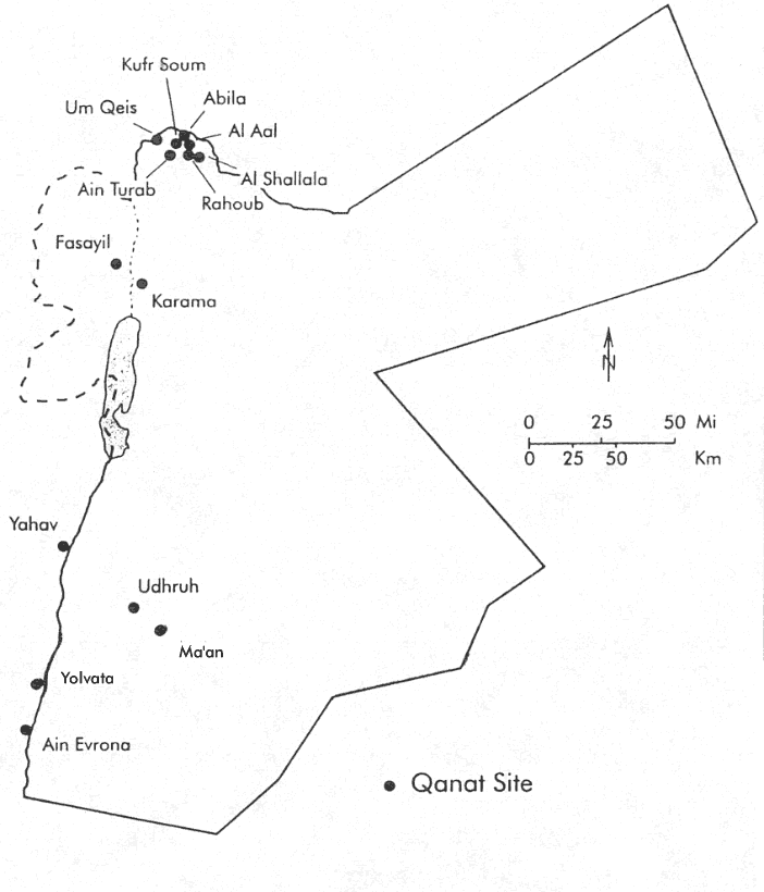
Figure 1. Qanat sites in Jordan (from original fieldwork data).
| Click on the image for a larger version. |
History of Jordan's Qanats
The precise dating of qanats is virtually impossible, unless their construction was accompanied by documentation or dated inscriptions. Most of the evidence we have for the age of qanats in any region is circumstantial, a result of their association with the ceramics or ruins of ancient sites whose chronologies have been established through archaeological investigation; or the qanat technology being introduced long ago by peoples whose pattern of diffusion can be mapped and dated; or a local oral tradition establishing qanats as pre- or postdating other events whose dates have been more firmly established.[5]
Jordanians today (at least those few who are aware that qanats exist) refer to qanats as "Roman canals", or qanat Romani (kaneh Romani in northern Jordan, sarab ["underground canal"] in southern Jordan). However, the term Romani is commonly applied to ancient features in this region, and it also can be interpreted to mean "pre-Islamic" or simply "old" and not necessarily "Roman".
With few exceptions historic irrigation systems in Jordan seem to date mainly from Roman times. The Romans (64 B.C. to A.D. 330)[6] and their eastern Roman empire successors the Byzantines (A.D. 330-630) gave to Jordan (and Syria) a great number of aqueducts and wells; they improved irrigation techniques in the region and expanded arable land, and it was during the centuries of Roman supremacy that the Levant entered upon a period of unsurpassed prosperity.[7]
Numerous pottery fragments and ceramic oil lamps, found in and around qanats, have shown clearly that qanats in this region were constructed in Roman times and used during the Byzantine era.[8] Historical records also show that the Romans constructed qanats in Jordan, Tunisia, and other places throughout their empire;[9] or at least the Roman political-economic system organized and funded the labor needed to build qanats, though the engineers and laborers were likely natives of the region in the employ of the Roman state.
The interiors of some qanats in northern JOrdan are marked with crosses and other Byzantine inscriptions,[10] and Near Eastern qanats are spatially associated with Roman-Byzantine sites. For example, 40 percent are sited in the immediate vicinity of smaller Romano-Byzantine outposts and guardhouses.[11] Every qanat in Jordan is adjacent to Roman and Byzantine settlements or outposts. Because the supporting evidence is strong, most scholars believe that Jordan's qanats were built by the Romans and used by the Byzantines from the 1st century B.C. to the 7th century A.D.
Some of these qanats continued to be used during the early Islamic period, when the Umayyad caliphate (A.D. 661-750) controlled agriculture and trade in this region. Some of Syria's qanats were even built during Umayyad rule, when the Islamic empire was at its political and geographical zenith, Syria became the most prosperous province of any Islamic caliphate, and agricultural production was expanded through much of the region.[12] The diffusion and historic utilization of qanats throughout the Old World - from the Iberian peninsula to central Asia - mirrors the historic dispersal of Islam.
The Umayyad contribution of Jordan's qanats is less clear. Features associated with Umayyad culture-ceramic shards, oil lamps, settlement, and agriculture - have been found in and around qanats in the Arava Valley and at Udhruh, Ma'an, and Abila,[13] and irrigation systems in the Jordan Valley were maintained under the Umayyad caliphate.[14] Therefore, the Islamic Umayyads appear to have utilized at least some of the qanats they inherited in this region, but this whole area remained marginal to Umayyad trade, and demand for agricultural products from this peripheral region began to fall off after its severance from Byzantium.
By A.D. 750, the Islamic Abbasids had conqured the Umayyads and established the caliphate in Baghdad. Syria was reduced to a province within this empire, and Jordan was further marginalized. By the middle of the 8th century in Jordan, after accession of the A???? dynasty, there began a gradual retreat of agriculture from the frontiers established under the Roman and Byzantines, many settlements and agricultural sites were abandoned and overrun with Bedouin tribesmen,[15] and none of Jordan's qanats were used after this time (with one brief exception noted below).
So long did the qanats of Jordan lay abandoned that knowledge of their existence or their original purpose fell away from oral history in the region. Fanciful tales were concocted to account for the presence of these chains of wells - variously described as defensive pits or wells built for thirsty armies by local heroes and conquerors - stories sometimes repeated today by the few people who are aware that chains of wells (or qanats) exist in the country. In contrast to Syria, where most farmers and villagers have at least heard of qanat Romani, the frequent absence of the very concept of subterranean aqueducts in the rural Jordanian tradition suggests that there were never many qanats in Jordan and that they have lain abandoned for a very long time.
Material culture and a few fragments from oral tradition suggest that the qanats of Jordan were originally constructed by Romans. Yet there were many Roman sites that never operated qanats, including the Decapolis cities, the largest Roman settlements in the region (fig. 2).[16] Obviously, then, something more than the "presence of Romans" affected where and to what extent qanats would be built in this region.
Ecology of Jordan's Qanats
Rainfall
Most of the qanats in Jordan (twenty-two of thirty-two galleries) were constructed in semi-arid regions receiving 100 to 300 millimeters average annual precipitation. This mirrors the pattern in Iran and Syria, where the major qanat systems are found where precipitation ranges from 100 to 300 millimeters per year.[17] Drier regions were not permanently settled by Romans or Byzantines and remained, as today, inhabited by nomadic Bedouin herdsmen not inclined toward irrigation- dependent sedentism. More humid settlements were rarely supported by qanat irrigation in Syria, or elsewhere throughout the Near East and North Africa, yet six sites in Jordan (containing ten qanat galleries) are clustered around the south bank of the Yarmouk River, in an area receiving 400 to 500 millimeters average annual precipitation. However, settlement in Jordan, even in mountainous regions with their more abundant rainfall, is possible only near springs and wells where provision is made for storing winter rains; ten times the amount of land is needed to support a family or settlement in this region when agriculture is entirely dependent on rain rather than some form of irrigation.[18]
Yet factors other than rainfall alone must account for the existence of qanats in this northwest corner of Jordan. For example, this is the area of Jordan most heavily and permanently settled by Romans, since it is contiguous to the more humid and more heavily settled areas of the Mediterranean littoral, and this is one of the most favorable areas in Jordan for constructing qanats with regard to the suitability of aquifers.
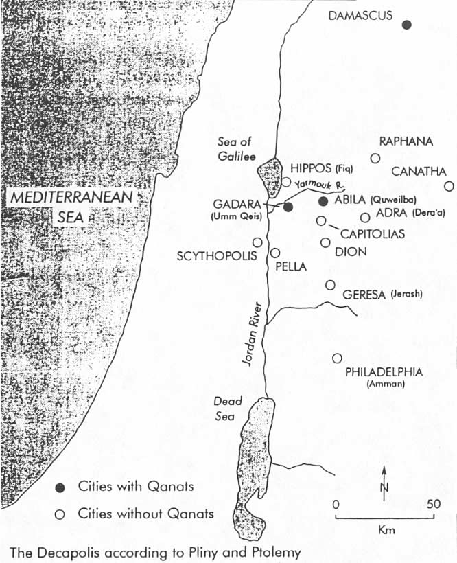
Figure 2. Roman Decapolis cities with and without qanats (contemporary names of these settlements are provided in parentheses).
| Click on the image for a larger version. |
Topography and Hydrology
Because qanats tap into shallow aquifers - in alluvial fans or synclinal (down-folded or basin-shaped) rock beds - at the base of hills or mountains, or along the margins of larger wadis (stream channels) coming out of the mountains, there is a close relationship between qanats and upland topography. All of Jordan's qanats were constructed within the piedmont (French, literally "foot of the mountain") zone, mostly at elevations of 1,500 to 3,000 fett, with the exception of the qanats at Ma'an, which lie only 10 kilometers from a high range of hills and tap into aquifers fed from those highlands. Where groundwater is available farther from the uplands, it tends to be brackish and otherwise of poorer quality than water found in or very near the mountains. Therefore, the uplands supply qanats with both a greater quantity and a better quality of groundwater, and they were never built beyond the montane (mountain area) piedmont zone.[19]
In most of the steppe and desert regions of Jordan and Syria, deposits of silica (e.g., quartz, chert, flint) often form impervious layers beneath the permeable calcareous (calcium carbonate) formations nearer the surface.[20] It is in regions with these conditions that the Roman engineers exploited the water-bearing strata to build qanats, tunneling most of their channels through solid beds of limestone.
In most of Syria, limestone and chalk aquifrs are relatively shallow- a few meters to tens of meters deep. Some of the same tertiary and quaternary period carbonate rocks comprise aquifer beds in Jordan, but they are far less accessible. In most of the country, groundwater lies at depths greater than 100 meters, the result of water horizons being drained and the water level lowered by the main rift (geologic fault depression, the Jordan and Arava valleys) in the west and the large, deeply eroded wadis which cut inland and draw water out to the rift valley.[21]
In a few of the areas settled by Romans, however, water-bearing rock or gravel is found closer to the surface - as shallow as 5 to 20 meters around Ma'an-Udhruh and in Jordan Valley.[22] Two qanats near Ma'an and a multibranched gallery at Udhruh (each varying from 2 to 5 kilometers in length) were cut into hard limestone aquifers at depths of 5 to 10 meters. Nineteen now obliterated qanats around Karama once tapped into the shallow (7 to 17 meters) water-bearing gravles of alluvial fans (fan or cone-shaped masses of stream-deposited sediment), which move down into the Jordan Valley from the western slopes of the Moab Mountains.[23] All along the rift valleys of Jordan - the Jordan Valley and the Arava Valley - there are numerous gravelly wadis flowing out of mountains, creating many alluvial fans and bajadas (ramps of sediment along a mountain base) that could be tapped by qanats. However, qanats have been found in these valleys only around Karama on the east bank of the Jordan, around Fasayil on the west bank, and on the west side of the Wadi Araba (see fig. 1).
Scholars who have studied qanats on the western (Israeli) side of the Arava Valley have either speculated or asserted, without the proof of seeing, that qanats also must exist on the east bank of the valley.[24] However, Burrows and Speiser surveyed both sides of the valley during the British mandate era and, as I did, found no evidence of qanats on the eastern (Jordanian) side.[25] This seems logical if we consider the pattern of settlement and transportation in the ancient Arava Valley. The Nabateans, predating the Romans in this region, established a trade route along the eastern side of the Arava Valley, and there is evidence that Romans, too, had traveled this path.[26] But the oases on the western side of the Arava Valley - those served by qanats - were situated on the primary high road linking the Red Sea port of Eilat, via the Negev, with the populated regions to the north and northwest.[27]
Qanats in the north of Jordan - near the Yarmouk River - are deeper than those found elsewhere in the Levant. Each of the qanats at these seven northern sites is cut into a thick limestone bed to depths of 10 to 60 meters, and they vary in length from 1 to 6 kilometers.[28] The hydrologic conditions characteristic of the Yarmouk region of Jordan, presumably, are duplicated on the north (Syrian) bank of the Yarmouk River. Yet in spite of the fertility of this latter region - known as the Hauran plain, the granary of Syria - not a single qanat was constructed there. Unlike the landscape south of the Yarmouk, where limestone comes to the surface and many qanats are found, the northern (Syria) Yarmouk Valley is completely covered by an extensive basalt (fine-grained volcanic rock) flow which originates in the eastern Golan Heights, covers much of the fertile Hauran plain of southwestern Syria, and runs to the very edge of the gorge that overlooks the Yarmouk River. The volcanic soils of the norht bank are generally better for agriculture than the limestone soils of the southern (Jordanian) side,[29] but qanats were never constructed in basalt zones because of the difficulty of boring qanat shafts through basalt and because basalt, or other impermeable surface materials, will inhibit recharge to underlying aquifers.[30]
One additional aquifer characteristic may help further to account for the limited use of qanats in this Roman frontier: groundwater transmissivity, related to the ease of water flow through an aquifer. Even if a greater area of Jordan had been underlain by shallow aquifers, allowing Roman engineers to exploit groundwater with qanats on a grander scale (assuming, of course, the political economic impetus to build more qanats existed), the utility of qanats still would have been limited by the slow rate at which groundwater with qanats on a grander scale (assuming, of course, the politial-economic impetus to build more qanats existed), the utility of qanats still would have been limited by the slow rate at which groundwater flows through most aquifers in the region. More transmissive groundwater flow is relatively rare in Jordanian aquifers;[31] and though early qanat engineers were not apprised of these hydraulic flow rates, they were surely aware of the spatial variation in natural spring flow, which is affected by aquifer transmissivity.
The combination of shallower aquifers with more transmissive groundwater flow provided the best conditions for exploiting underground waters with a qanat, and such ideal conditions in Jordan are exceedingly rare (fig. 3). Yet all of the qanats in Jordan were constructed in areas underlain by shallow aquifers with transmissive flow, and very few of the areas that possess these characteristics were ignored by Roman qanat engineers.
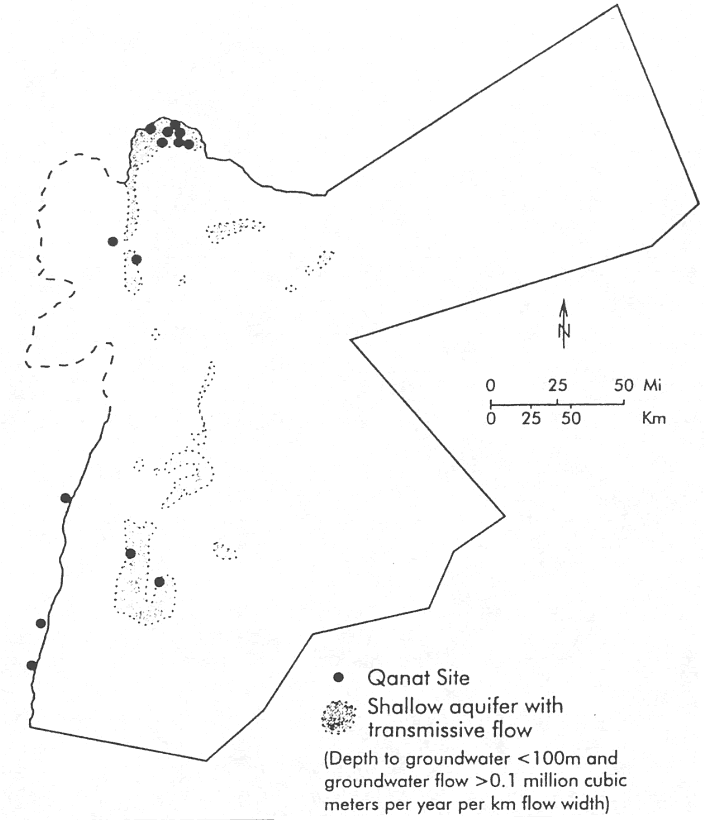
Figure 3. Best aquifer conditions for qanats in Jordan. Shaded areas indicate shallow aquifers with transmissive flow.
| Click on the image for a larger version. |
Qanats in a Modern Levant
In most of the world where qanats are found, they have continued to provide irrigation and drinking water to farms and cities well into this century, and qanats still function in parts of China, Afghanistan, Pakistan, Iran, Iraq, Oman, Saudi Arabia, Syria, Egypt, Algeria, and Morocco. But in each of these areas in recent years, qanats have been challenged by newer hydraulic technologies - especially the mechanically pumped tube well - which have led to epochal abandonment of qanats as social systems have undergone corresponding change and water tables have fallen. Modern technologies never had the chance to compete with qanats in Jordan, however, because qanats were abandoned there centuries ago - long before drip irrigation, modern dams, and pumped wells were introduced - with one notable exception.
Six qanats around Karama in the Jordan Valley were reopened in the 1920s by Amir Abdullah's engineers and used for irrigating about 600 hectares of fields and gardens near the winter palace of Abdullah, the titular ruler of early Jordan. Gardens once again flourished in this desert where no cultivated plants had thrived since the Byzantine period.[32] Beginning in the late 1930s, private farmers began buying land from Abdullah's state holdings around Karama, including those parcels irrigated with qanats. In the early 1960s, farmers in the region began installing diesel-pumped wells in order to increase the supply of water for irrigation, but as more water was withdrawn from local aquifers than was being recharged, the water table around Karama fell, and all of the qanats dried up by 1970. A coup de grace was dealt to these qanats when they were permanently effaced in 1975 by the Jordan Valley Authority, which used earthmoving equipment to level the ground all around the Karama region in preparation for an extension of the East Ghor/King Abdullah canal.
Summary
Throughout the history of Levant, Jordan has straddled the frontier zone separating the desert and the sown, which always has been the decisive factor affecting the economic proseperity of the region. This boundary between the settled cultivators and the pastoral nomads is an extremely dynamic one, fluctuating one way or another from one year to the next and migrating great distances over longer spans of time.[33]
Sedentary agriculture can prosper only during periods of efficient and stable government, and at no time in the history of the Levant has so much land between the desert and the sown been brought under cultivation as during the Romano-Byzantine period.[34] Qanat irrigation in Jordan was developed and abandoned as these early Levant empires waxed and waned. When their settlements disappeared or their populations dwindled, the maintenance of qanats ceased, and qanats were abandoned. Qanats were an important source of irrigation in neighboring regions, including Syria - one of the breadbaskets of the Roman empire and an important source region of agricultural commodities for subsequent Islamic empires.[35] But even the more humid and hospitable areas of Jordan were neither breadbasket nor political hearth. In constrast to Syria, Jordan remained at the periphery of the Romano-Byzantine and early Islamic empires. As a result, it was never settled as completely, its resources were never exploited as intensively, and it remained more prone to a form of boom-and-bust economy as the strength and influence of these empires waxed and waned, usurping the people and resources at their margins and then retreating back to their core areas. Furthermore, most aquifers in Jordan have poor transmissivity, are found at great depth, and were far less accessible to the builders of qanats than those in Syria. The general inaccessibility of groundwater in Jordan, combined with the failure of early Levant empires to integrate this volatile border zone fuly into their trade and transportation systems, conspired to inhibit construction of and reliance upon qanats in the early settled areas of Jordan.
Note: This article is excerpted from "Qanats in the Levant: Hydraulic Techonology at the Periphery of Early Empires," Technology and Culture (38:2) 1997, pp. 432-451.